

- It’s what we do
- Kennedy Range
- RJAYS Adventure Suit
- Keeping Balance
- KTM 390 Adventure
- Final Flinders Fling
- Glory Days
- V-Strom: Old Vs New
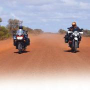
- Our unique Outback Ride Experience
- Yamaha WR250R
- Texas
- Very Fine Batsman with Mike Ferris
- Wheelies: Part One with Miles Davis
- Sand, The Great Divide with Andy Strapz
- Not To Plan: Part One with Karen Ramsay
- Checkout
- Fit Out
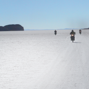
Solo mission Final Flinders Fling Hopper farewells his 1090R.

2019 saw Easter and ANZAC Day close together, and that meant I only had to take three days annual leave to gain 10 days of freedom.
I normally head to Cameron Corner for the Easter weekend, and, with a few extra days, an obvious extension to that was South Australia’s mighty Flinders Ranges.
A new 790 was on its way, so it was time for a final fling on the big girl – the 1090R – which had been with me for the past 15 months.
Good Friday
Departure from Newcastle was at 7.00am and with the temperature at a very pleasant 18º C I breezed through Denman, Merriwa, Dunedoo and into my first stop at the Dubbo bakery. With double-demerits in place the time taken was just over four hours and I rewarded myself with the usual pie, apple turnover and extra-shot coffee, and of course some 98-octane for the 1090.
From Dubbo I pushed on to Narromine then followed backroads and finally dirt into Warren for another splash of fuel and a final check of luggage.
This was where the real riding started.
 Author Hopper and his 1090R. A new 790 was on its way, so it was time for a final fling on the big girl.
Egged on
There was more dirt as I headed for Canonba and Brewarrina, taking Monkey Face Road as a more interesting option, a 10km link road across to Gongolgon. Plenty of ’roos in large groups kept me alert, and as I pushed on over mixed terrain to Tarcoon, plenty of ’roos, goats and emus and a big patch of deep sand about halfway almost brought me undone – thankfully I stayed upright – past Mount Oxley turnoff to join the Kamilaroi Highway for an easy run into Bourke.
A fuel top up after a 325km leg was welcome and finished an 840km day before settling in for a good night at the Port Of Bourke Hotel. The normal buffet set-up had been replaced with a traditional pub menu and was thankfully still a good, filling feed.
Being Easter, the annual Back To Bourke weekend was in full swing with a big crowd and a very loud band, but, as it was Good Friday things shut down at 10.00pm.
 Just over 4500km in nine days.
Saturday
One of the reasons I stay at Port Of Bourke is the secure parking, although this time I was blocked in by the chef’s car. Thankfully a young bloke was on hand to man-handle the beast clear and allow me to leave at 8.20am.
The first 80km out of Bourke on the notorious Bourke-to-Wanaaring Road was tar – 35km extra since last Easter – and now there’s only 110km of dirt and sand. Several sections still get the heart rate up though, like when I caught up to a Kombi van on a 20km stretch of deep sand. There was no way to pass in the total whiteout so I had to stop. That caused me to lose my mojo and it took me a while to get to the well-stocked Wanaaring Store for a good catch up with Ben and Margaret.
The next 250km section of dirt was in great condition and included a close encounter with two large eagles who were very reluctant to leave the road-kill feast they were enjoying. I also stopped to pick up a tent from the middle of the road – almost certainly from one of the three bikes I’d passed going the other way. A ute pulled up so I gave the driver the tent hoping he would catch the bikes at Wanaaring. The temperature was in the high-30s, so Tibooburra servo with its cool beverages was a welcome sight.
A run north out of town towards Warri Gate and through Olive Downs Station, once part of Sidney Kidman’s pastoral empire, included several old dams and tanks to check out. One had plenty of water, but a cow floating in the middle didn’t make it real inviting.
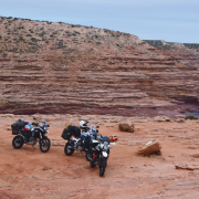
Jump-up Lookout was certainly worth the slight detour, and from there a track joined Toona Road, out through the Dingo Fence via the Toona Gate, and a sandy track through to Nocconora Road and Cameron Corner completed a 650km day. I shot the obligatory photo at the cornerpost marking the intersection of the three states (NSW, Queensland and South Australia), then had a great evening with Wayne and Greg on a KLR and 1200GSA. We had a top feed and a few ciders to wash down the dust.
 An old, yellow, 1952 double-decker bus used to be parked at Twilight Bore. Unfortunately, with people not doing the right thing, the bus is no longer there.
Bored
Cameron Corner was in the rear-view mirrors at 8.00am on a fine, but very cloudy, Sunday morning as I headed west.
The road was sandy but well-packed past Bollards Lagoon and red flags marked large holes which were usually just over the crest of the many dunes.
The 1090 roared past Twilight Bore where an old yellow 1952 double decker bus used to be parked. I’d camped at the bus several times in the past, but, unfortunately, with people not doing the right thing the bus is no longer there.
The shortcut track linking this road to the Strzelecki Track and saving around 70km is now closed as well, and it’s due to people not doing the right thing.
There were several quite sandy sections as I got closer to Merty Merty and joined the Strzelecki Track.
The Strzelecki is now an iconic Australian outback track, but originally it was created by a cattle thief trying to move 1000 head of cattle from South Australia to Queensland. Back in the 1870s (when the editor was a boy) it would’ve been quite a feat.
Montecollina Bore was the first stop of the day. There’s no facilities at the bore, but it’s an excellent camping spot and great for a dip. Fed by a hot spring bubbling from the ground, it’s not as warm out in the middle. Two couples in 4WDs arrived and we had a good chat.
 Tibooburra was a welcome sight (servo with cool beverages not shown).
Onward
After a swim I was back on the beast and heading south for Arkaroola.
I knew I needed to turn at Mount Hopeless and head through Moolawatana Homestead, but the GPS was playing up and tried to take me along fence lines with no tracks. I stopped to glare angrily at the screen, and I wasn’t there long before one of the 4WDs from the bore pulled up. I explained I was looking for the turn. The lady in the passenger seat responded,“I have a map right here.”
I heard something about ‘35kms to the turn off’.
Enquiries showed the 4WD was travellingat around 90kph. I was moving a bit quicker than that, so, offering my thanks, I set my trip meter and took off.
About three kilometres down the road I sailed past a faint track on the left with a very small sign. At 30kms I started to watch for tracks. By 45kms I’d seen no turn offs at all. I definitely had enough fuel for my intended route and was fairly confident I could make it to Lyndhurst, but I certainly couldn’t go back.
 The Strzelecki was created by a cattle thief trying to move 1000 head of cattle from South Australia to Queensland.
Caught short
Long before Lyndhurst I had to fuel from my RotoPax, and the trip meter showed 450km as I rolled into town. I was very low on fuel and headed straight to the servo, only to find it closed and offering only diesel via credit card.It was the same at the pub: diesel only.
I gingerly pressed on, covering the 33km to Copley and, it being Easter Sunday, found it closed as well.
I finally made it to Leigh Creek. The trip meter showed 500km and my 23-litre tank took 23.1 litres. Thankfully, someone upstairs was looking after me.
Out to Arkaroola via Nepaburra I went,logging 620km for the day.
While I was having a cool ale at the bar, the lady who’d given me directions earlier came up (obviously recognising my good looks).
“We were worried at the way you sailed straight past the turnoff not long after we spoke,” she said. Apparently she’d said ‘three to five kilometres’. With my earplugs in and helmet on I’d heard ‘35km’.
We all had a good laugh at my expense.
The only option for a feed was the $30 all-you-could-eat barbeque, and it turned out to be a good one. I met Bevan on another 1200GS, and he turned out to be Greg’s brother from the night before at Cameron Corner.
After plenty of tall tales and cold ales we called an end to a really good night.
 Cameron Corner completed a 650km day.
Steep
Plunger coffee from a neighbour made a relaxing start to the next day, which I’d decided to spend doing some of the local tracks at Arkaroola Sanctuary.
After some pointers from reception I headed to Paralana Hot Springs, which turned out to be very rough, rocky and slow going on the 1090.
I’d had the bike lowered so I could at least get the balls of my feet on the ground, and the lack of ground clearance was an issue several times.
A reasonable hill climb detoured to a water tank for good views. There was one vehicle in the parking area at the Springs, and it was two older guys in a 4WD with a flat. I changed the tyre for them, then walked a kilometre or so up and down stream. Upstream was very picturesque, like walking through a painting. I found water but no obvious springs. I backtracked along the 4WD track into Arkaroola Springs and found one small, stagnant pool with dozens of ’roo carcasses. There were several live ’roos too, but only just. It was quite depressing really, to see the drought taking hold.
The Mount Jacob Backtracker 4WD trail was rutted and rough but had great views, and I joined the main road before taking Station Backtrack back to base.
A steep detour to Frome Lookout was rewarded with great views and I arrived at the campsite at around 4.00pm for another great evening with fellow campers.
 The obligatory photo at the cornerpost marking the intersection of the three states (NSW, Queensland and South Australia).
Boared
With not much planned for the fifth day I eased into it. Coffee was again supplied by the friendly 4WD campers, and I was happy to chat. They were two motorbike cops away with their families and they had some interesting stories and even a few tips.
I left Arkaroola at 10.30am and had a good run through to Blinman for a nice lunch, including one of their famous quandong pies at the general store – a quandong is a wild peach, an Australian native bush food, and very nice.
A good winding descent down to Parachilna Gorge followed a creek lined with large river red gums and I noted some awesome campsites. The Angorichina Tourist Village has a well-stocked one-stop shop where I enjoyed an ice-cream and cool drink before joining the main highway at Parachilna, well-known for the Prairie Hotel and its feral-food dishes. I’d sampled some on previous trips, and they’re nice, but pricey.
From there a brief squirt down the tar had me on the road to Brachina Gorge, then an adventure rider’s favourite,Bunyeroo Gorge which runs through the Heysen Range. It was great riding, and after the steep climb out several awe-some lookouts with good parking offered stunning views of the ranges, including Wilpena Pound. Razorback Lookout was the pick of them, I thought.
 The road was sandy but well packed.
Good advice
Out onto the main Hawker-Blinman Road I thumped.
I’d booked accommodation at Willow Springs homestead but rang them to check on availability of a feed. I was advised there was no food sold on site, so I detoured to the well-stocked Wilpena Pound minimart for a few tins and cans.
Back toward Willow Springs I went, stopping at Hucks and Stokes Hill Lookouts where a large number of people had parked waiting to watch the sunset. Apparently, it’s really good from there, but I didn’t want to be heading into camp in the dark so I kept rolling.
My reason for staying at Willow Springs was to do the famous 4WD Sky Trek the next day. I asked the lady running the place if it was suitable for large adventure bikes.
“No worries,” she replied. “A large group did it today on big bikes. Why don’t you go and talk to them?”
I tracked them down to find they were all on 250s and 450s, and their consensus was, “Don’t do it on a big bike…especially the last 20km.” They pointed out there were lots of large bulldust holes with big rocks buried in them, and even the small bikes had struggled.
Back to my nice little cabin I went to cook up a feast with a nice few ales, and even watch some TV.
Washed up
A sleep-in made for a very relaxing start to the following day, the sixth of my ride.
I sat out on my own veranda in the middle of the bush and sipped a nice coffee.
With Sky Trek off the agenda I had a day to spare, so I headed south and side-tracked into Sacred Canyon. It was 14km of dirt plus a short walk into a beautiful little gorge with some engravings, and I could see why the place had special significance.
I trundled into Rawnsley Park hoping for accommodation, but found it fully booked out, so I rang ahead and booked into Hawker Caravan Park.
After a long, late, lunch at Hawker chatting to fellow adventure riders, I even managed to do some washing – after five days my socks were very ordinary, to say the least.

Nice folks
ANZAC Day kicked off with a service right opposite the caravan park. Some 200 people attended and shared plenty of ANZAC biscuits and chatting.
Although the weather had been fine for me, both north and south had experienced several days of heavy rain and roads to the north were definitely closed. That made it an easy decision head south, where the GPS sent me 30km on a track into a private property with no through road. I eventually found Craddock and headed east to Old Baratta Station, then onto the main road to Yunta. The ruin of the Old Waukaringa Hotel was worth a photo stop. From the ruin you can see a chimney at the old gold-mining site, and a track takes you there. There are other remnants to explore as well, but care is needed.
Having fuelled bike and belly at Yunta I didn’t fancy the 200 clicks up the Barrier Highway to Broken Hill, so I asked at the servo about a road on the map through Lilydale Homestead then east to Broken Hill. I was clearly told the road was rough, but access wasn’t an issue (the locals would know wouldn’t they?).
I punted 70km to Lillydale on a good dirt track but couldn’t find any tracks going east as shown on the map, so I went into the homestead and found an old stockman.
“Yeah, mate,” he gummed. “There used to be a track, but it no longer exists.”
He advised I’d need to keep going to Oatdale Station, and although not on the map, a track went through to the Silver City Highway.
I pressed on.
The track was mostly good with some deep sections of soft sand just to keep me on guard, and at the entrance to Oatdale Station an old car (dating back to the editor’s time) and a sign pro-claimed 192km to Broken Hill.
I pushed on through Loch Lilly Station, even after sunset, emerging on to the Silver City Highway with still about 90km to Broken Hill. Fuel was an issue again.
The GPS said the nearest fuel was at Coombah Roadhouse, 28km the other way. ‘That’ll do me,’ I thought, and arrived not long after – to find the place all locked up with a pay phone that didn’t work. Thankfully a lady came out and
allowed me to use the roadhouse phone to report in to The Bride. The lady also volunteered her reluctant husband to cook me a pizza and let me set up the tent on their lawn.
The day finished with a nice pizza and chat.

Roughing it
I was packed and ready to go by 8.00am to avoid being in the way of any customers, but I purchased breakfast, fuel and a strong coffee and waited till 9.00am when the RMS was due to update road conditions. By 9.15am nothing had changed so I pushed on over the 30km of highway then took the dirt haulage road towards the Ginkgo Zircon mine, then picked up the road to Pooncarie.
Pooncarie allowed a fuel top up before coffee and cake at the little café on the Darling River. I checked out the historic wharf site, which, back in its day, was very active with paddle-steamers plying the wool trade from outback NSW and Queensland to South Australia.
George at the local store warned me about the state of the road from 30km to 60km out of town and he was spot on. During that 30km stretch there were plenty of long sections of deeply rutted bottomless sand. Knowing I should’ve been floating over the top of it (like the editor would) didn’t help. Instead, I did plenty of first-gear paddling on the big girl.

As I neared Ivanhoe there was plenty of evidence of heavy rain, and apparently the Cobb Highway
had only just reopened. I fuelled up and pressed on.
Unfortunately, the two normally good dirt options to Hillston were closed due to the heavy rains, so I did a 140km stretch on the Cobb Highway to Booligal. From there the Lachlan Valley Way dirt road to Hillston was open, but very chopped up from the rain and some very interesting navigation was needed to get through and around the obstacles.
A splash of fuel at Hillston set me up for the run to Lake Cargelligo, but due to time restrictions and road conditions it was tar the whole way.
The mirrors were filled with a great sunset as I pulled up and booked in to a $40 pub room with a good feed and loud music – which thankfully stopped at 10.30pm.
 At the entrance to Oatdale Station a sign proclaimed 192km to Broken Hill.
Rewarded
It was a cool morning as I made my way down to the lake for photos.
It was a bit of an ugly situation at the start of the day as I was unable to get a real coffee anywhere in town and set off along the back way to Condo uncaffeinated. I trundled past the airport and followed the Lachlan River past the weir. There were some great camping spots and I stopped to check out the painted utes which used to be Utes In The Paddock at Ootha, 30km east of town, but are now just outside Condobolin. The display is certainly worth a browse.
The bakery supplied real coffee, cake and a pie and then I was on the backroads, a lot of which had been tarred since my last visit.
From Filfield I followed a nice little dirt option to Tullarmore then Narrowmine and Dubbo for another bakery and fuel stop and then the Golden Highway took me home.
It was a most enjoyable trip. I covered just over 4500km and the bike performed well – it was only the rider who let the side down a few times.
And as a special treat for getting home a day early I was dragged along to Spotlight for several hours exciting shopping.
There’s definitely a lesson there!


Comments