Advrider Older Magazines

Cape York

0
This entry is part 24 of 24 in the series Adventure Rider Issue #3

All great adventure ideas start somewhere. Steve and Paul began theirs at the local, promising to reach all points of Australia eventually – north, south, east and west. The first destination was Australia’s most northern point, Cape York.

Just a week before we were due to leave everyone bailed, and Steve and I thought it’d be just the two of us.But then good mate Dave said, “I have an idea. I’ll take both my Ténérés and bring my friend Mark.”

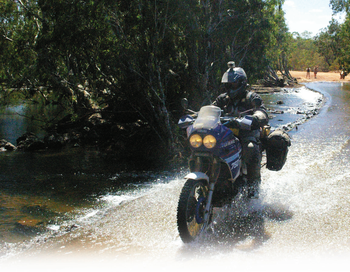
That balanced the numbers: two Suzukis and two Yamahas. A DR650, DR250, Ténéré 600 and a Super Ténéré 750, and before we knew it we were bunked down in Cairns, ready to go.

What plan?

We awoke to find the CREB Track closed, so our first day consisted of 80 per cent tar. We didn’t hit the dirt until Cape Tribulation, 110km north, and we couldn’t wait to get to the Bloomfield Track. It’s a nice, flowing road with some knee-deep water crossings marked with warning signs for crocodiles. We were on one of few bridge crossings when we saw our first ‘snappy handbag’, a 2.5-metre salty. We pulled up and took photos for those who wouldn’t believe us.

The famous Lions Den Hotel, just short of Cooktown, was our first nights’ accom, offering a camp, pizza and a few celebration coldies. It was there at the pub we met Oliver, an English backpacker who’d ridden from Victoria on an XR650, and invited him to tag along for the trip. After way too many coldies we made an executive decision to go to Cape Melville.

There was no plan in the itinerary to go to Cape Melville, and we had no research on the terrain, but what’s an adventure if you’re going to stick to a plan?

There and back

The next day we headed for Cooktown to stock up on tackle and fuel and venture up to the lighthouse for photos with 360-degree views.

After the complicated task of getting an e-permit (a pre-booking for a campsite within a Queensland National Park) we had lunch and ended up at the police station to ask if there was a shortcut across to the Starke Track.

“Are you guys off to Cape Melville?” enquired the officer. “It took us five-and-ahalf-hours to get there on our last recovery”.

Nevertheless they were very helpful and told us of a trail that turned out to be a blast, twisting through banana plantations and making a change from all the cane fields further south.

Everything was fine as we continued up the Starke Track, and then, with panniers hitting the ruts, we regrouped about 10km into the bulldust and found it was already 4:30pm. A LandCruiser approached from the other direction, so we flagged it down and exchanged terrain stories. The driver told us there was another 50km of rutted bulldust to reach the Cape Melville turn off, then another 56km to our destination.

We made a decision right then to return to the Endeavour Falls Tourist Park and hightailed it south to get as much distance as we could before nightfall. It was 120km to the park, and 10km would be the bulldust we’d just ridden through.

The evening came rushing down as we went looking for our second night’s accommodation.

Croc head

Now back to our itinerary. We headed for Battlecamp Road, through Lakefield National Park, stopped at the Old Laura homestead for a few photos and then Kalpowar for a bite to eat.

This day’s leg wasn’t that difficult, so we arrived at Musgrave in the early afternoon to fuel up and have a few coldies before calling it a night. Musgrave Roadhouse has a swamp behind it and if you look carefully there are ‘freshies’ in there.

Pfft. Freshies. They were still worth a photo.

Fruit Bat Falls.

Signs of where

Up the boring Peninsula Development Road to Weipa we went, saying goodbye to Oliver at Coen. He was starting to have a few issues with his bike…so he said. I think he’d just decided we were mad.

Archer River Roadhouse provided lunch, and the Ténéré boys were ahead for once when I got a flat 70km from Weipa. They were almost at Weipa when the Super Ténéré ran out of fuel and they waited for us. They were waiting a while!

The night’s stop was at Weipa Caravan Park, where we found Dave’s Super Ténéré was running really rough and the carbon-fibre exhaust on my DR650 had broken its rivets. Thankfully we’d planned the next day to be a rest day, and the exhaust was shortened with no problem. Unfortunately for Dave the Yamaha had sucked dust, and he decided to fly back to Cairns to pick up his LandCruiser and trailer and return to camp by the next morning.

He flew out on a noon flight and, true to his word, was back in camp at 6.00am.

Cross my Palm Creek

The plan for the following day was to complete the southern section of the Old Telegraph Track, then head east to Captain Billy’s Landing.

The bike and trailer was dumped at Moreton Telegraph Station and we headed for Bramwell Junction, the gateway to the Old Telegraph Track. This is where you choose between two options to arrive at the Jardine River Ferry. You either go up the Old Telegraph Track or the Bamaga Road, and our plan was to tackle the Old Telegraph Track. We were informed that this was the driest wet season for many years and the water levels at the creek crossings were well down, so we fuelled up and only four kilometres down the track found the first crossing at Palm Creek. The creek itself was only a trickle, but it was the entry and exit that were the fun bits.

After that, a couple of easy creek crossings had me a bit complacent and I entered a crossing to see the headlight go under and the bike cut out. Mark on the Ténéré 600 had the same problem. Steve made it through, and Mark and I got lucky with both bikes firing up after a little coughing and splattering.

The road to Captain Billy Landing, once off the Bamaga Road, is a sweet firetrail. As everyone says, Captain Billy Landing is windy, but bearable. We set up camp, set up a camp television and had a few well-deserved coldies.

Get the point

Captain Billy Landing was like a fivestar hotel. With the crashing of the ocean, we awoke early, keen to hit the northern section of the Old Telegraph Track, and our destination was Vrilya Point.

We arrived at Fruit Bat Falls, an oasis, there’s no other way to describe it. After days and days travelling on the corrugated Peninsula Road and then the sand of the Old Telegraph Track, it was like arriving at a day spa.

We had to eventually move onto the next oasis, Twin Falls, just 12km north. This place was just as good, but daylight was getting away from us and we reluctantly decided it was time to tackle the northern section of the Old Telegraph Track, and this is when we came across 15 or so fellas on their Massey Fergusons with their wives tagging along in the support 4WDs. It was a convoy of around 25 vehicles with an average speed of 30kph. Good on them I say.

Cypress Creek has a log bridge that would be eventful if a 4WD and a camper trailer were to come through this way. The LandCruiser only just fit!

Nolans Brook Crossing has the same reputation as Gunshot Creek, if not more infamous. It’s a deep crossing but there’s a three-log bridge about 20m to the left and we nursed our bikes across.

After consultation with the GPS we found the infamous bridge over Crystal Creek, and the following 30km road had sandy sections that would test the best. It seemed like every time we got into a great rhythm we arrived at a corner (and there aren’t that many on this road) where we had to suffer through 60cm-deep sections of fine sand for 100m and then back to great fire trail.

Eventually we got to Vrilya Point. What an amazing sight the Gulf Of Carpentaria presented. We found out we had to ride up the beach for 10km or so to get to the head for some great fishing. This was incredible. We set up camp and threw a few lines in. You wouldn’t want to be anywhere else!

We were planning to have a rest day, but despite the perfect location, we were all just too keen to get to the top the next day.

Beach mission

After a few hairy moments with wild pigs the next morning we got back to the Bamaga Road and the Jardine River Ferry, and from there to the WWII plane wrecks near Bamaga Airport. In 1945 a DC3 came down not long after take-off, killing all five on board. Just near there are two other plane-crash sites to visit also.

We started to head north again and, after 40km or so, stopped off at the Croc Tent store for some souvenirs.

The last 15km to the tip was swampy, dark and eerie terrain, and once you reach the end you have to park and walk approximately 500m to the top, then wait in line for that photo of the little sign that says “You are standing at the northernmost point of the Australian continent”. With our task completed it felt a bit surreal.

Done and dusted

We were happy to have completed our first of many missions and glad we’d made it all in one piece.The lady at the Croc Tent had told us about a five-beach ride on the east coast of Cape York, over near Somerset Ruins. I’m glad she recommended this, as it was a great way to complete our day. It’s not very often you get to ride on a beach, but five adjoining beaches was fantastic.

We headed for Loyalty Beach on the west coast for celebration duties to finish off.

The final days

We headed south in the coming days, not seeing anything along the way as we did most of it on the way north. My rebuilt exhaust didn’t last long due to the 30cm-deep corrugations on the Bamaga Road and the remains of it now reside on the number-plate tree at Bramwell Junction, making for a long, noisy return trip.

We do have unfinished business at The Cape: Frenchman’s Track, Starke Track and the CREB Track. Dave has to complete the adventure on his now newly built 850 Super Ténéré and by the time we return, ‘corrugation concussion’ will have been totally forgotten.

Overall it was a great experience and I highly suggest you plan your own trip soon

Series Navigation<< It’s What We DoThe Adventure Challenge >>

It’s What We Do

Previous article

The Adventure Challenge

Next article

You may also like

Comments

Comments are closed.